Short answer: the Nazca Lines are one of archaeology's most studied and least explained sites — thousands of lines, shapes and figures etched into the southern Peruvian desert roughly 2,000 years ago by a culture that left no written record explaining why. This guide covers what the geoglyphs actually are, the science behind how they've survived two millennia largely intact, the leading theories about their purpose (and why none of them is fully settled), the AI-assisted research that has nearly doubled the known figures since 2024, and the practical decision every visitor has to make: fly over them, or view them from the ground.
What the Nazca Lines Actually Are
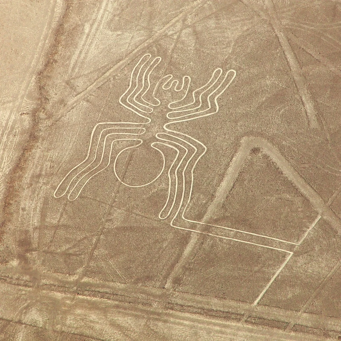
The Nazca Lines are geoglyphs — large-scale designs made directly on the ground rather than built up from it — spread across the Pampa Colorada ("Colored Plain") and surrounding desert plateau near the town of Nazca, in Peru's Ica region, roughly 400 km south of Lima. Archaeologists group them into three broad categories: more than 800 dead-straight lines, some running for tens of kilometers across the plain; over 300 purely geometric shapes, including triangles, spirals, trapezoids and zigzags; and a smaller, more famous set of pictorial figures depicting animals, plants and human forms — the hummingbird, monkey, spider, condor and killer whale being among the best known.
Attributed to the pre-Inca Nazca culture, which flourished in the region from roughly 500 BCE to 500 CE (with later contributions into subsequent centuries), the site was formally recognised by UNESCO as the Lines and Geoglyphs of Nasca and Palpa World Heritage Site in 1994. The designation covers both the Nazca plain itself and a related, slightly older set of geoglyphs near the neighbouring town of Palpa, which are less visited but historically significant in their own right.

How the Geoglyphs Were Made — and Why They've Survived 2,000 Years
The technique itself is straightforward, even if the scale and precision achieved with it are not. The Nazca desert floor is covered in a layer of reddish-brown stones, darkened over millennia by iron-oxide weathering, sitting on top of a paler, yellowish subsoil. To draw a line or a figure, Nazca artisans simply cleared the dark surface stones away along the outline of the design, exposing the lighter soil underneath. The resulting grooves are shallow — typically only 10 to 15 centimeters deep — which makes their survival for two millennia genuinely remarkable.
That survival comes down to the region's climate rather than any preservation technique. The Nazca plateau is one of the driest, most stable environments on Earth: rainfall is minimal, and the wind that does blow across the plain moves fast enough at surface level to lift loose dust away without disturbing the heavier stone borders that outline each groove. In effect, the desert itself has acted as a natural climate-controlled archive, protecting the lines from the erosion that would have erased a similar design almost anywhere else in the world within a few decades.
Why Were They Made? The Leading Theories
This is the question the Nazca Lines are best known for, and it remains genuinely unresolved after more than 80 years of formal study. A few theories have earned the most scholarly credibility:
- Astronomical and agricultural calendar. American historian Paul Kosok, who observed the lines from a small plane in 1941, first proposed that certain lines aligned with solstices and other celestial events, functioning as a giant calendar for a farming society dependent on predictable seasons.
- Ritual pathways tied to water. Given how central water scarcity was to life in one of the world's driest deserts, several researchers, including Maria Reiche in her later work, have argued the lines and trapezoids relate to water sources, irrigation planning, or rituals intended to summon rain.
- Pilgrimage and ceremonial routes. Some lines appear to converge on or lead toward Cahuachi, a major Nazca ceremonial center, suggesting certain lines were walked as part of religious processions rather than simply viewed.
- Messages meant for the gods. Because most figures are only fully legible from the air or from elevated terrain, some scholars argue they were never meant to be seen by people at ground level at all — but by deities looking down.
None of these theories fully explains every category of line, shape and figure, and it's entirely possible — likely, even — that different lines served different purposes across the centuries the site was in use. Reputable sources are consistent on one point: claims connecting the Nazca Lines to extraterrestrial visitors have no supporting archaeological evidence and are not taken seriously within the field.
The 2024-2025 AI Discoveries: Nearly Double the Known Figures
For most of the past century, the pace of discovery at Nazca was slow: roughly 430 figurative geoglyphs were catalogued through traditional aerial photography and fieldwork by the time researchers began exploring a new approach. In 2024, a joint research project between Yamagata University's Nazca Institute and IBM Research, published in the Proceedings of the National Academy of Sciences, used an AI model trained on high-resolution aerial imagery to flag likely geoglyph locations for field verification. The results were striking: 303 new figurative geoglyphs identified and confirmed in just six months, roughly a sixteen-fold increase in the historical discovery rate.
The AI proved particularly effective at spotting smaller, fainter "relief-type" figures — depicting humans and domesticated animals like camelids — that are far harder for the human eye to distinguish from natural terrain than the giant, better-known line-type figures showing wild animals. Researchers believe these smaller figures served a different, more everyday function: markers along walking trails rather than large-scale ceremonial designs. In 2025, at Expo Osaka's Peru Pavilion, the same team announced a further 248 new geoglyphs, bringing the confirmed figurative total to roughly 893 — meaning more than half of everything currently known about the Nazca figures has been discovered within the past two years.
How to See the Nazca Lines: Flight vs Tower
Because most of the major figures were designed at a scale only readable from above, seeing them properly comes down to two realistic options. Here's how they compare.
| Factor | Small-plane overflight | Observation tower (Mirador) |
|---|---|---|
| What you see | Full scale and geometry of ~10-13 major figures | 2-3 figures (e.g. hands, tree, lizard), partial angle only |
| Duration | 30-35 min from Nazca; ~1h35-1h40 from Pisco/Paracas | 15-30 min visit |
| Approx. cost | $85-120 from Nazca; $300-380 from Pisco, plus taxes | S/3-7 entrance fee |
| Physical demands | Banking turns can trigger motion sickness | Minimal — a short climb up the tower |
| Booking | Best booked in advance, especially in peak months | Walk-up, though remote without your own transport |
| Best for | Travelers who want the complete picture and don't mind small planes | Budget-conscious travelers or anyone nervous about small aircraft |
Flying over the lines
Overflights typically depart from Nazca's María Reiche Neuman Aerodrome and last around 30-35 minutes in small, window-seat-for-everyone aircraft, circling roughly a dozen of the most significant figures while a bilingual guide narrates each one. Longer flights are also available from Pisco or Paracas for travelers based on the coast rather than in Nazca itself. Expect a pre-flight weigh-in for balance, a safety briefing, and separate airport and tourist-site taxes on top of the base fare.
Viewing from the tower
The 13-metre Torre Mirador de las Líneas de Nazca, beside the Pan-American Highway, offers a free-standing, ground-level alternative that requires no flight at all. The view is genuinely limited compared to a flight — you'll make out two or three figures, and only from a partial angle — but it's inexpensive, quick, and a reasonable option for travelers on a tight budget, prone to motion sickness, or simply passing through on an overland Lima-to-Cusco route.
Best Time to Visit and Getting There
The Nazca desert's extreme dryness means there's no real rainy-season concern the way there is in the Andes or the Amazon — visibility is generally good year-round. What does vary is the wind: mornings, roughly before 10:30 am, tend to be calmer, giving a smoother flight with less of the aggressive banking that can trigger motion sickness later in the day. Nazca town sits about a 6-hour drive south of Lima along the Pan-American Highway, or roughly 3.5-4 hours from Ica or Paracas; most visitors combine a Nazca Lines flight with a stop in Paracas or Huacachina on an overland route between Lima and Cusco or Arequipa.
Beyond the lines themselves, the surrounding area holds several other Nazca-culture sites worth combining into a visit: the Chauchilla Cemetery, with naturally mummified remains still visible in situ; the Cantalloc Aqueducts, an underground irrigation system engineered by the Nazca that remains partly functional today; and Cahuachi, believed to have been the culture's principal ceremonial center.
Ask us how it fits your route.
Before You Go: A Practical Checklist
Book your flight in advance if your dates are fixed
Overflights aren't always available same-day, particularly in busier months, so booking ahead removes one variable from a trip that's already tightly scheduled around a Lima-Cusco route.
Choose your operator carefully
Given the site's flight-safety history, prioritise established operators with a clear safety record and recent reviews over the cheapest quote you find.
Fly in the morning if you're prone to motion sickness
Earlier flights are generally smoother; if turbulence and banking turns are a concern, ask your operator about their earliest available slot.
Bring your passport and expect a weigh-in
Small aircraft require accurate weight distribution, so be prepared to be weighed at check-in, and bring ID as required for the flight manifest.
Consider the tower if budget, time or comfort favour it
It won't replace the view from the air, but it's a legitimate, low-cost way to see the site if a flight doesn't fit your trip.